Drilling Engineering Answers to Short Questions
Answers to Short Questions 2004 Model Exam:
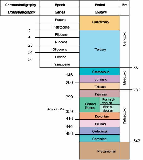
A1. Cenozoic, Jurassic, Eocene (exact numerical ages are not important)
Cenozoic is the name of an Era, meaning “young life”. Cenozoic contains Tertiary and Quaternary periods, and is less than 65 Myrs Before Present
Jurassic is a Period name (named after Jura Mountains) in the Mesozoic “Middle Life” - the age of the Dinousaurs – 136-190 MyrsBP
Eocene is an Epoch in the Tertiary 37-53 MyrsBP
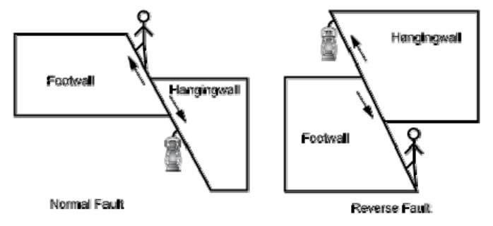
A2. Hangingwall and footwall
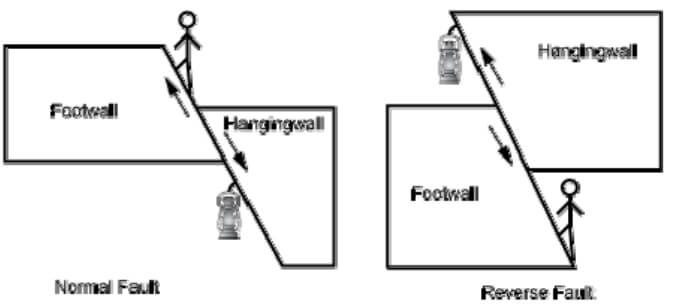
These terms relate to the blocks on either side of a dipping fault plane. The terms are derived from old mining terminology. The block or rock mass that hangs above the fault plane is called the hangingwall, while the block that lies below the fault plane is called the footwall.
A3. Secondary migration
Migration of oil (or other hydrocarbons) from the kitchen area immediately outside the source rock, through a carrier bed to a reservoir is called secondary migration, as opposed to primary migration which is the migration of oil out of the source rock.
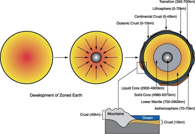
A4. Crust and lithosphere
These refer to the outer layers of the Earth. Crust and part of the Upper Mantle together form the Lithosphere, the solid outer layer of the earth that moves on the more plastic Astenosphere. The crust can be subdivided into Continental and Oceanic crust, depending on how it is formed.
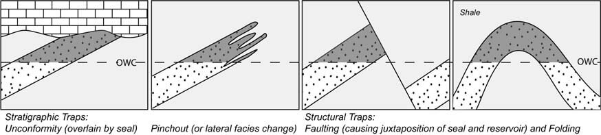
A5. Trap
A trap is the arrangement of reservoir and seal layers in the subsurface to form a volume that is able to trap oil (or hydrocarbons) – traps may be one of two kinds, structural or stratigraphic. Structural traps are caused by tectonic movement of layers creating a sealing arrangement (such as faulting) or a geometric shape (such as folds) that can trap oil.
Stratigraphic traps are formed by stratigraphic changes (such as pinchouts or unconformities) that (assuming the rocks are dipping) can trap oil.
A6. Frequency and wavelength of sonic waves
Wavelength (λ ) is the length of a cycle, or the distance between two peaks (maxima) or troughs (minima) of succeeding cycles.
Frequency (f) (measured in cycles per second or Hz) is the number of cycles to pass an observation point in a second.
The two are related by the following formula:
λ=V/f
Where V is the velocity of the wave in the medium through which it is travelling.
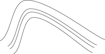
A7. Asymmetric anticline
An asymmetric anticline is an upfold which has different lengths of its limbs.
A8. Gross rock volume
The entire volume of rock (both porous and non-porous rock) contained between the top of the reservoir and the hydrocarbon contact (or spill point).
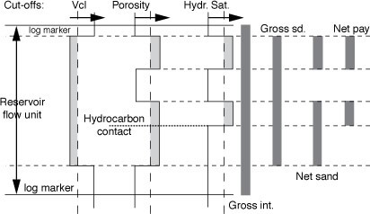
A9. Net-to-gross
The ratio of porous rock to the total volume in a structure would be one definition of
N/G, however N/G is often used in several different contexts, so that it is important when using this term to define exactly which sense of ‘net’ and ‘gross’ are being used. Commonly used in the sense of the partition of a vertical interval into parts that are “in” (net) or “out” (gross) by reference to cut-off criteria (clay content, porosity, and saturation).
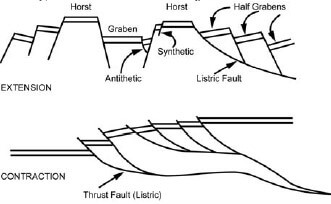
A10. Rift
A regional-scale system of sub-parallel, normal faults that lead to a composite, deep and narrow depression, with multiple high and low regions within it. Usually filled with sediment deposited during the time of the deformation, and possibly with associated volcanic deposits.
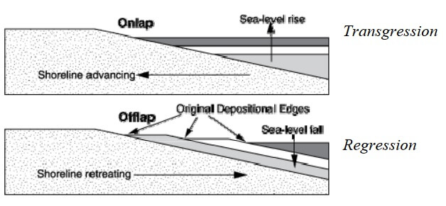
A11. Transgression and regression
These are terms used to describe the movement of the coast line (caused by relative sea level rise and fall). Transgression occurs when relative sea-level rises, and the shoreline therefore moves land-wards, causing onlap of marine sediments. Regression occurs when the relative sea-level falls and the shoreline moves sea-wards, causing offlap and downlap relationships in marine sediments.
A12. Listric faults
Faults that are “spoon-shaped”, with the shallow portions of the fault dipping steeply, and the deeper parts dipping more gently. These faults can occur in both extensional and
contractional settings (i.e. the faults can be either normal or reverse). Rotations of the adjacent rocks will always occur due to the shape of the fault.
A13. Formation tops
Distinctive lithological changes in the rock column that represent the top of some formation (a formation is a mappable, lithologically distinctive unit, often formally named and recognised over a wide area). Normally we would expected to be able to correlate formation tops across some distance (field-wide, for example). Usually identified by name and measured/subsea depth in a well.
A14. Two-way-time
Time taken for a seismic pulse to travel from the surface source down to a sub-surface horizon, reflect from it, and return to the surface.
A15. Intra-reservoir shales
Shales that occur within reservoirs. These may be continuous layers, or possibly discontinuous layers, that will impact the vertical permeability and connectivity of different layers within the reservoir. Many different environments are prone to intra-reservoir shales, including fluvial sandstones but especially amalgamated or partially amalgamated turbidite beds.
A16. Normal and reverse faults
Both are dip-slip faults (where the slip direction is parallel to the dip of the fault plane). Normal faults occur in extension regimes, and the hangingwall moves down relative to the footwall. Reverse faults occur in compression regimes, and the hangingwall moves up relative to the footwall.
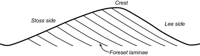
A17. Cross-bedding
A sedimentary structure resulting from deposition of sediment on the downstream dipping lee surface of a subaqueous or subaerial megaripple or dune. The megaripples or dunes migrate downstream in the strong unidirectional current, eroding the ‘stoss’ side of the previous bedform, so that the preservation of cross-bedding relies on there being sufficient accommodation space to allow deposition of part of each successively migrating megaripple or dune
A18. Primary porosity
Porosity formed during deposition of the sedimentary rock, by the relationships of the grains to one another (the texture of the sedimentary rock, grainsize, sorting and packing primarily), and also any porosity within fossils (particularly important in carbonate rocks). This is distinguished from secondary porosity which results from post-depositional processes, such as dissolution or fracturing.
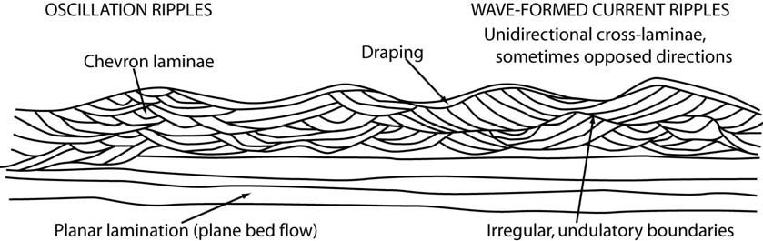
A19. Wave ripples
Wave ripples are bedforms caused by gentle currents indicating bi-directional flows. Wave ripples are usually symmetric in shape, occasionally with bifurcating crests. The internal sedimentary structure of a wave ripple will consist of small cross-laminations in both directions, or chevron shaped.
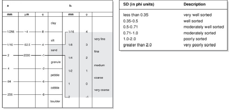
A20. Grain size and sorting
Grain size of a sediment is the average grain size of the particles – i.e. clay, silt, very fine, fine, medium, coarse, very coarse sand. Sorting refers to the variations in grain size, with well-sorted materials having a narrow range of sizes, and poor sorting indicating a wide range of particle sizes.
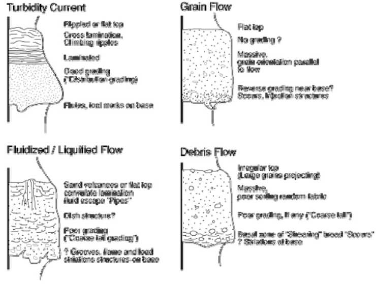
A21. Gravity flow deposits
When sediment is mixed with water it will be denser than water without sediment and
will flow under gravity – e.g. turbidity flow. Gravity flow deposits occur in a wide variety of environments, including onland (landslides, mudflows, debris flows) to underwater (turbidity flows). The ratio of sediment to water within the flow generally governs the type of particle interactions that take place, and therefore the physical behaviour of the flow (speed, distance, erosive power etc). The deposits from gravity flows are always poorly sorted, since a wide variety of sediment is being carried and often flows of this nature ‘freeze’ when they run out of slope. However, some deposits, notably turbidity flows, deposit the material they carry in a more orderly manner, with coarse material being deposited first and then finer material afterwards, leading to a ‘fining-upwards’ succession being formed.
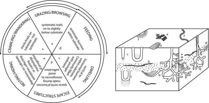
A22. Bioturbation
Action of biological fauna on unlithified sediment. Immediately after deposition the sediments are colonised by animals, which either burrow into the sediment or travel along the surface, creating burrows, tracks and trails. The burrowing animals usually destroy primary sedimentary structures as they move through the sediment in search of organic particles to eat. Bioturbation refers to any mixing of the sediment by the actions of biota, and a measure of severity is often associated with it – e.g. minor bioturbation or extensive bioturbation.
A23. Stratigraphic correlation
Stratigraphic correlation is the art of correlating logs by examining the relationship of lithological units (rock units with the same properties) to one another. Often this is done by aligning the log sections along a stratigraphic marker. The purpose of stratigraphic correlation is to enable us to see thickness variations and the degree of lateral connectivity of depositional (lithologic) bodies.
A24. Walther’s Law
Layers or facies occurring in close vertical proximity (in a complete section with no unconformity) will have been deposited in close lateral proximity.
A progressive shift of the depositional setting (e.g. by a process such as transgression) will lead to a vertical stacking of different depositional environments over the course of time.
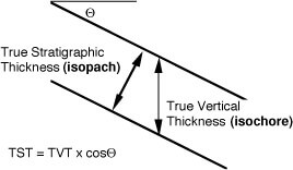
A25. True vertical thickness
This is the thickness of a bed measured in a true vertical direction, as opposed to the ‘stratigraphic thickness’ which refers to the thickness of the bed measured perpendicular to the bedding surfaces (depositional thickness). A contour (line joining all points of equal value) of the true vertical thickness would be an isochore, while a contour of stratigraphic thickness would be an isopach.