
Petroleum Geoscience Model 11
Answers to Section A:
A1
Describe the concept of heterogeneity, and how calculating the coefficient of variation for permeability data helps to define formation heterogeneity (Note that heterogeneity is not equivalent to heterolithics).
(2 marks) Heterogeneity refers to the variability of a property (any property) spatially within a rock unit. Highly heterogeneous rocks have very variable properties, relatively homogeneous rocks have similar properties throughout.
The coefficient of variation (Cv) is a measure of variance, and is commonly calculated on permeability data:
Cv = SD / kar
(standard deviation divided by arithmetic mean of permeability data). For permeability, a Cv below 0.5 means the samples are from a homogeneous rock, between 0.5 and 1.0 means a heterogeneous rock, and above 1.0 the rock is very heterogeneous.
A2
What are unconformities (definition and examples)?
(2 marks)
Unconformities are surfaces between older and younger rock layers, where there is a significant difference in time that is not represented by preserved rock layers. This ‘missing time’ can be due to non-deposition during that time period, or due to erosion of material subsequently. There are three main types of unconformities: Angular unconformities (where older rocks have been folded or deformed before being eroded and younger rocks deposited on top, creating an angular relationships across the unconformity surface); disconformities (or parallel unconformities, where there is no difference in dip between older and younger layers, but there is evidence of erosion along the unconformity surface); and paraconformities (or non-depositional unconformities, where there is no evidence of erosion, and the missing time is assumed to be the result of non-deposition).
A3
What do the terms LKO, TVD, DATUM, and Feather-Edge refer to in volumetrics?
(2 marks)
LKO – Lowest Know Oil TVD – True Vertical Depth
Datum – A datum is a reference level. The datum on a cross section is subsea depth and on a correlation a stratigraphic marker.
Feather-Edge – area between outer and inner OWC’s. Part of the field with bottom water.
A4
What are megaripples (draw a diagram)?
(2 marks)
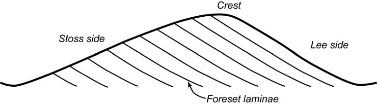
Megaripples are bedforms generated by unidirectional flow. They are greater than 5 cm in height, with variable wavelength depending on grainsize and current strength.
A5
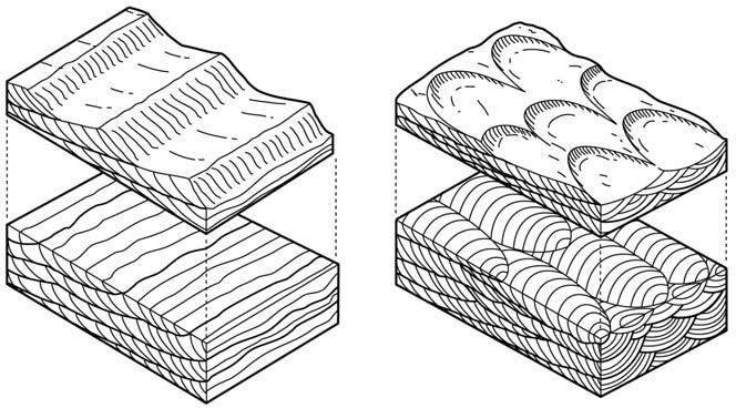
What is cross-lamination (draw a diagram)?
(2 marks)
Cross-lamination is a sedimentary structure formed by the migration of
ripples in a unidirectional current. Each set is less than 5 cm thick. Cross-lamination can be either trough or tabular, caused by migration of curved crested and straight crested ripples respectively.
A6
What’s the difference between STOOIP and Reserves?
STOOIP is the total volume of oil in the reservoir (measured at
(2 marks)
atmospheric pressure), while reserves are those quantities that can be extracted, which is a percentage of the STOOIP. The amount recoverable is determined by the recovery factor.
A7
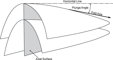
What is a Plunging Anticline (draw a diagram)?
An anticline (upfold) with a non-horizontal or plunging axis:
A8
What quantities are depicted on maps by drawing Isopachs and Isochores?
(2 marks)
(2 marks)
Isopachs are contours of true stratigraphic thickness, and isochores are contours of true vertical thickness.
A9
What is TWT, and where is it used?
(2 marks)
TWT is two-way-time. It is the time taken for a seismic wave to travel from source into the subsurface, and back to the receiver. It is used as the scale in printing seismic lines. If the velocity of the rocks is known, then half the TWT multiplied by the velocity will give you the depth to a horizon.
A10
Which of the following is strictly correct if a permeability field is anisotropic?
- Vertical permeability and horizontal permeability are different
- Porosity does not correlate with permeability
- Permeability in the dip and strike direction are the same
- Permeability Coefficient of variation > 1
(2 marks)
Only 1 is strictly correct
A11
What are stratigraphic traps (draw diagrams to illustrate the different types)?
(2 marks) Traps are containers of reservoir rock, bounded by sealing rocks to prevent the hydrocarbon migrating out. Stratigraphic traps are those where the container is formed by stratigraphic processes, although often some structural tilting is required. Unconformities that truncate reservoir layers and are overlain by sealing rocks form traps, and pinching out facies (that are tilted) are another example of stratigraphic traps.
A12
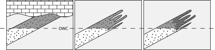
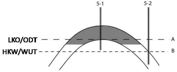
What does the abbreviation HKW stand for, and draw diagrams to illustrate the difference between the cases where you have OWC, HKW and LKO.
(2 marks)
HKW = highest known water. This is used where a well has not
intersected the OWC, so that you have a level of lowest known oil (LKO) and HKW, between which the OWC must exist.
A13
What do the terms transgression and regression mean?
(2 marks)
Transgression refers to a rise in relative sea level, where the shoreline will move towards the land. The architecture of sediments deposited during this move will be onlap. Regression refers to a fall in relative sea level, where the shoreline will move towards the basin. The architecture will be offlap.
A14
The following diagram shows a series of beds through which a seismic survey has been taken. Assuming that the source and receivers are at the top surface illustrated, and that the seismic waves are travelling straight up and down between the bed surfaces, at what two-way-time will the reflection caused by the bed boundary be observed at the receivers?
Is this reflection likely to be positive or negative?
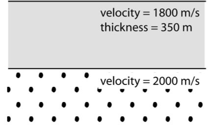
Reflection is likely to be positive (smaller to larger velocity, which suggests smaller to larger impedance). 0.389 seconds.
A15
Which of the following statements are true, as defined by the SPE?
- Probable 50% probability of this volume plus proven being produced or exceeded
- Possible 10% probability of this volume being produced or exceeded
- Probable 50% probability of this volume being produced or exceeded
- Proven more than 90% probability of this volume being produced or exceeded
(2 marks)
1 and 4 are correct
A16
What is Primary Migration, and how does it differ from Secondary Migration?
(2 marks) Primary migration is the movement of hydrocarbons from the source rock into the surrounding rocks after generation within the source rock.
Secondary migration is the movement of hydrocarbons away from the
source rock area, via carrier beds or within the hydrodynamic flow of the basin.
A17
What is the difference between relative and eustatic sea-level (draw diagrams to illustrate your answer)?
(2 marks) Relative sea-level refers to movements of sea-level relative to land-level not necessarily caused by increase or decrease of global sea-levels.
These can be caused by tectonic movements locally or regionally, or by sedimentary infilling of accommodation spaces or by changes in global sea-level (the mechanism is often not specified because it is not known). Eustatic sea-level is where the global sea-level is changing, either due to change in the volume of water or in the volume of space available in the oceans (climatic or tectonic mechanisms).
A18
What effect does grainsize (the average size of the grains in a rock) have on porosity and permeability in (a) sediments and (b) sedimentary rocks?
(2 marks) Grainsize should have no effect on porosity, however it does due to the changing shape of grains with smaller grainsize. In sediments porosity increases with decreasing grainsize, as the irregularly shaped grains prop each other up creating large void spaces. However after compaction the trend is reversed, as these irregularly shaped grains tend to pack down closer together, reducing overall porosity in fine grained sedimentary rocks.
Permeability is directly affected by grainsize, as the size of the grains controls the size of the pores and thus the pore-throat sizes, the smaller the pore throats, the lower the permeability, so that fine grained sedimentary rocks have lower permeability than coarse grained sedimentary rocks.
A19
What is the purpose of lithostratigraphic correlation?
(2 marks)
To show the connection or non-connection of lithologic units in the subsurface, and to therefore identify flow-units, connections between wells, likely reservoir connectivity, extent and volume.
A20
Two siliciclastic successions consisting of sheet-like sediment bodies are being studied:
- comprises repeated large-scale coarsening upwards cycles, starting with bioturbated mudstones and ending in cross-bedded to laminated coarse sandstones,
- comprises thin fining-upwards beds of fine sandstone grading upwards into mudstone, with no trend in grainsize or bed thickness observable at
What depositional environments would you suggest each succession has been deposited in?
(2 marks)
- large-scale coarsening-up cycles with bioturbated mudstones at base suggest shallow marine
- Thin beds of fining-up sandstone without an overall trend suggest turbidite beds – deep marine
A21
What are carbonate sedimentary rocks?
(2 marks)
Rocks composed of carbonate minerals – calcite, aragonite and dolomite are the main culprits. Calcareous carbonates are often composed of the remains of organic life – that is shells and bones of organisms, or secretions of encrusting organisms. Dolomites are often secondary (diagenetic), or are precipitated directly from solution.
A22
Copy the following diagram into your answer book, then add these labels to the diagram:
- Normal fault
- Reverse fault
- Hanging wall
- Footwall
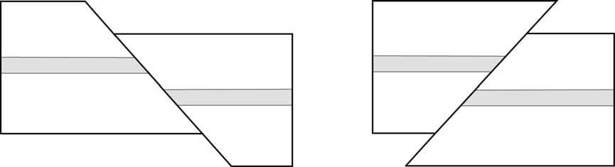
Normal Fault Reverse Fault
Footwall Hanging wall Hanging wall Footwall
A23
What recognition criteria could you use to identify aeolian deposits?
(2 marks) Red-bed association (red colouring due to oxidised iron, association comprises fluvial, alluvial deposits in association with evaporites and dune deposits).
Lack of clay and mica. Large-scale cross-bedding. Hierarchy of erosion surfaces. Foresets with grainflow and grainfall layering. Sheet-like dune deposits interbedded with more poorly sorted inter-dune deposits.
Evaporite deposits close to centre of basin, alluvial fans at margin.
…. Four of these, ½ mark each…
A24
What features do you look for in a good stratigraphic marker bed?
(2 marks) Distinctive, easily identifiable. Likely to have been deposited over a widespread area, or in many different depositional environments at roughly the same time. Time significance. Geophysical signature easily recognised.
…. Four of these, ½ mark each…
A25
Define the terms Mesozoic, Silurian and Oligocene, in terms of their position in the geologic timescale and their hierarchical level.
(2 marks)
Mesozoic is an era, between Paleozoic (older) and Cenozoic (younger). Silurian is a period in the Paleozoic era.
Oligocene is an epoch in the Tertiary Period of the Cenozoic Era.
Answers to Section B:
B26
a) Describe the calculation of the semivariogram from a line of data (porosity or permeability in a well). Identify nugget, sill and range.
(12 Marks)
Explain the calculation below
|
g (h) = 1 å[k ( x) - k ( x + h)]2
Perm
(mD) Lag 1 Lag 2 Lag 3 Lag 4 Lag 5
1220
1356 18496
1870 264196 422500
930 883600 181476 84100
5500 20884900 13176900 17172736 18318400
3400 4410000 6100900 2340900 4177936
2700 490000 7840000 3132900 688900 1806336
790 3648100 6812100 22184100 19600
1190 160000 2280100 4884100 18576100 67600
3650 6051600 8179600 902500 62500
4500 722500 10956100 13764100 3240000 1210000
3765 540225 13225 6630625 8850625
4600 697225 10000 902500 11628100 14516100
3700 810000 4225 640000 2500
950 7562500 13322500 7924225 12602500 7290000
47143342 69299626 80562786 78167161 41665661
14 13 12 11 10
Variance 1683691 2665370 3356783 3553053
2501170 0.673161 1.065649 1.342085 1.420556 0.832923
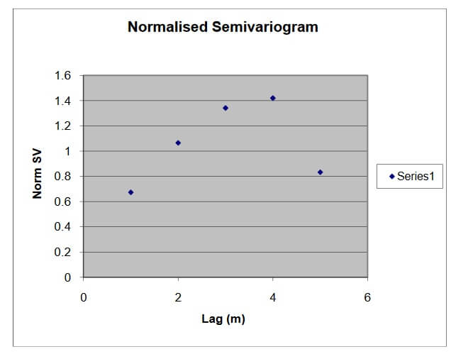
Nugget 0.25
Cyclical variogram – hole at Lag 5 Cyclical variogram – possible layering
Ideal semivariogram – no nugget, no hole, sill at 1.
a) How is anisotropy represented on a semivariogram plot (Note; you will need to show two semivariograms)
(5 Marks)
Show two variograms with different correlation length (and possibly sill) in horizontal and vertical directions.
b) What is the relationship between a semivariogram and a reservoir model? How do you go from the semivariogram to the model or vice-versa? Consider two cases in your discussion:
- when the grid block length is greater that the correlation length
- when the correlation length is ten times the grid block length
(8 Marks)
Experimental variogram interpreted with spherical model. Used to distribute block properties in the geological model with correlation. If correlation length shorter than block size then blocks are randomly distributed. If correlation length 10 time the grid block size then properties will be clustered (clusters of circ 5 grid blocks). In the former case cant extract the correlation length back out of the model.
B27
(a) Calculate the oil-in-place, given the following information:
There is no free gas in the structure
|
Oil water contact |
4750 feet below sea level |
|
Porosity |
0.18 |
|
Water Saturation |
0.15 |
|
Oil Shrinkage factor |
1.05 |
|
Net:gross |
0.6 |
(10 marks) The structure size can be estimated from the area (48sq km; 1200ac) and half the height (370ft, approx 100m) = 2.7 x 10^9 m^3. Student will have to know the formula for oil-in-place as directed in the notes.
OIP = ( GRV x NG x (1-Sw) x Por)/FVF
This gives 236million cu m or 1485 million bbls (0.225 cuKm or 8.25x10^9 cuft)
(b) How is net:gross calculated? How might it vary in a single well in a large structure like the one shown above? Your answer should consider the impact of varying correlation lengths and facies variability in different geological environments.
Net: Gross
(10 marks)
Gross – Gross interval – top to base of reservoir (Gross Pay: Top pay to OWC) Net – clay volume and porosity cut off
Representivity of a well over the reservoir volume is the key issue Heterogeneity matrix – horizontal and vertical correlation lengths Variable lithofacies – shallow marine, fluvial, turbdite
(c) How might variation in net:gross be incorporated into estimates of oil in place?
(5 marks) Variable net:gross needs a distribution (cdf) which can then be incorporated in a range of reserve estimates (Monte Carlo)
B28
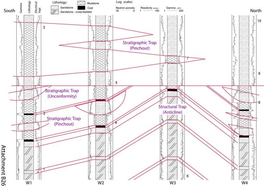
fluvial section as channels (1), correlating coals (1), correlating aeolian section across wells (1), correlating top and bottom of units (1), pinchouts correct (1), not correlating top and base of logs (1), correlating all changes of unit (1).
(b)
The base of the section is probably aeolian – the similarity of logs and the cross- bedding indicate this. Aeolian sands probably correlate well between logs. (1)
The change in elevation between each log probably indicates structural folding of the succession. (1)
The mid-part of the section (largely missing in W3), is probably fluvial – lack of sand correlation, presence of coals. The sand bodies therefore do not correlate (isolated channels) while the coals probably do. (2)
The top part of the succession is marine (given by the fossils) so the sands and muds are likely to correlate between wells (1) but sand is dominant in the north and pinches out to the south (shoreline is probably in the north) (1).
(c)
- The first event was the deposition of cross-bedded sands in an aeolian environment
- The cross-bedded (dune) sands are interbedded with more poorly sorted sands probably deposited in an interdune environment
- The climate changed, becoming much wetter, and swamps developed in the low- lying interdune areas, accumulating peat, which became coal
- A fluvial system developed in the area, with interbedded floodplain muds, swampy areas and fluvial channels
- The sediments were buried, probably lithified to form sedimentary rocks
- The sedimentary rocks were folded and uplifted, brought to the surface where erosion removed sediment and created a smooth erosional surface
- The folded rocks subsided below sea-level, and marine sediment began to be deposited on the eroded surface (forming and angular unconformity)
- Sediments were supplied from the north (sand) and transported out to sea (southwards)
- Eventually these sediments were also buried and lithified to form sedimentary rocks.
6 marks total – for starting with the oldest (1), for getting the order of deposition right (1), recognising unconformity (1), order of folding relative to deposition of marine rocks (1), giving reasons for changes (1), distinguishing sediments from sedimentary rocks (1).
- See answer to (a) – mark for each (4).
B29
(a) Contour each map using a 20 m contour interval.
- What is the technical term for each map?
(14 marks)
(2 marks)
- Draw a cross-section from A0 to A1, illustrating your interpretation of the
(5 marks)
- Write a brief description of the geological history that created the structure represented by your maps and cross-section (i.e. firstly x sediments were deposited, then they were folded and then faulted…)
(4 marks)
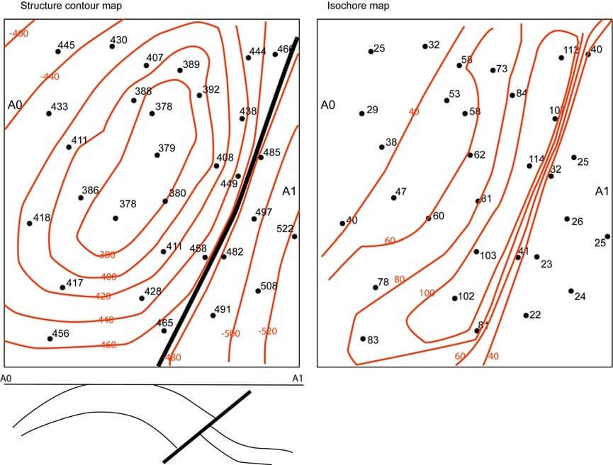
See above for A-C.
Essential points – contours labelled. Closed contours. Makes sense, all contours included, no missing contours or irregular contour intervals. It is possible to get full marks without including a fault. Similarly for the cross-section, as long as cross- section and map are the same, and either no vertical exaggeration or a stated, small VE has been used, full marks are possible.
D: Deposition of interbedded limestone/marl, deposition of sandstone succession while fault active (increase of thickness into fault shows growth fault type), deposition of mudstone 1. Inversion, erosion to form horizontal unconformity, deposition of mudstone 2.
